Background
In preparation for the attack on Tobruk, Division z.b.V. Africa issued a number of detailed drawings of the Tobruk fortifications to the assault troops, to help them in overcoming these. The fortifications were built by the Italian army.
Fortification Diagrams
Diagram 1: Schematic outline of the fortification line in the breakthrough sector.

- Concrete works at terrain level
- With 1-2 AT guns and 2-4 MG
- All round fortifications
- Continous and anti-tank ditch in forward line
- With partial wire obstacles and some minefields
- ‘Angreifer’ = attacker
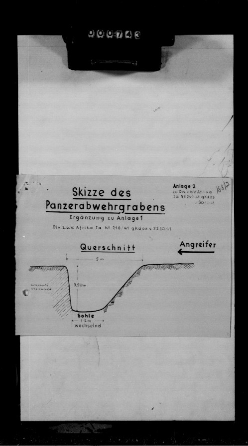
Diagram 2: Cut Diagram of the AT ditch.

- ‘Querschnitt’ = cross section
- ‘betonierte Steilwand’ = concrete vertical wall
- ‘wechselnd’ = changing
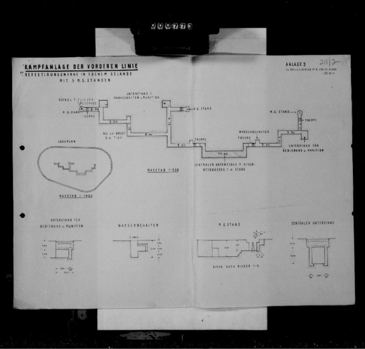
Diagram 4: Top-Down View of a Combat position of the forward line.

- ‘Befestigungswerke in ebenem Gelände mit 3 M.G. Ständen’ = fortified works in flat terrain with 3 MG positions
- ‘Sockel fuer Fliegerbeschuss’ = fixation point for AA fire
- ‘M.G. Stand’ = MG fighting position
- ‘Treppe’ – stairs
- ‘Unterstand für Mannschaften u. Munition’ = covered position for men and ammunition
- ‘Breit’ = breadth
- ‘Lageplan’ = overview map
- ‘Masstab 1:200’ = 1:200 Scale
- ‘Unterstand fuer Bedienung und Munition’ = covered position for operators and ammunition
- ‘Wasserbehaelter’ = water tank
- ‘Zentraler Unterstand m. Eisenbetondecke 1m Stark’ = central covered position with reinforced concrete roof 1m thick
Diagram 4: Detail of work of the forward line.

- ‘hinteres drahthindernis’ = rear wire obstacle
- ‘betonierter Graben’ = concrete ditch
- ‘z. Tl. getarnt, oder mit Stacheldraht ueberdeckt’ = partially camouflaged or covered with wire
- ‘Übergang’ = crossing
- ‘durchlaufender Flandernzaun zwischen den Werken’ = continuous wire/fence installation between works.
- ‘Tiefe’ = depth
- ‘vorderes Drahthindernis (versenkt) vermutl. mit S-Minen versehen’ = forward wire obstacle, dug in, probably with added anti-personnel mines
- ‘Querschnitt des vorderen Drahthindernisses’ = cross section of forward wire obstacle
Diagram 5: Combat position of the rear line.

- ‘Befestigungwerke in ebenem Gelände mit 2 M.G. Ständen und 1 PAK Stand’ = fortification works in flat terrain with 2 MG and 1 AT gun fighting position
- ‘PAK – Stand’ = AT gun fighting positon
- ‘Wasser’ = water
- ‘Befehlsstelle’ = Command Post
- ‘Beobachtungsloch’ = Observation hole
- ‘Eingang zum Unterstand’ = Entrance to covered position
- Others as forward line translations.
Diagram 5: Combat position with one MG fighting position.

- ‘Linke Stellung’ left fighting position
- ‘Verbindungsgraben’ = communication trench
- Other translations as before

Where did you get these drawings from? And is there a way you could post higher resolution images of them?
LikeLike
Where did you get these drawings, and any way you could upload higher resolution images of them?
LikeLike
Hi, these are from German war diaries. I’ll have a look see regarding resolution. The war diaries are held at NARA
LikeLike
They are still visible on google map
https://www.google.ca/maps/@31.9502392,24.027781,145m/data=!3m1!1e3?fbclid=IwAR1afWI6BA7O2H97PJRt-lM9N-9enKFhrkQL6g2uu3QzXY7CrLX_v6KVjeg
LikeLike
The Google map traces would appear to be the “support positions” which were behind the “front line positions” on the anti tank ditch / wire. These were generally even numbered ( e.g. S10, R14, etc ) while the forward positions were odd numbered ( e.g. S11, R15 etc. ). If anyone has more information I would love to know. Are there any surviving photographs of the concrete fortifications ? Obviously, anyone wandering around the area during the siege with a camera would probably end up against a wall, but perhaps there may be some pre-war photos ( Italian engineers ? ), or early post war photos. El Adem was a RAF base until mid 1960’s, so perhaps off duty personnel may have been interested.
Google maps also shows similar fortification traces around Bir El Gubi, and to the west of Sollum along the border.
LikeLike
Dear John
I think there are quite a few pictures on the IWM website that show at least part of the fortifications. I may have some pictures of similar fortifications too, and will add them to the article.
The numbering of the positions was as follows:
1) All positions were inside the AT Ditch, uneven positions forward, even positions rear. They were offset against each other.
2) Positions were lettered (from west to east) S/R/Z
3) S-positions from the coast south to Ras Mdaur
4) R positions east towards Azazi then north to the Via Balbia (Bardia Road)
5) Z Positions at Marsa Zeitun, starting from Via Balbia north to the coast
All the best
Andreas
LikeLike